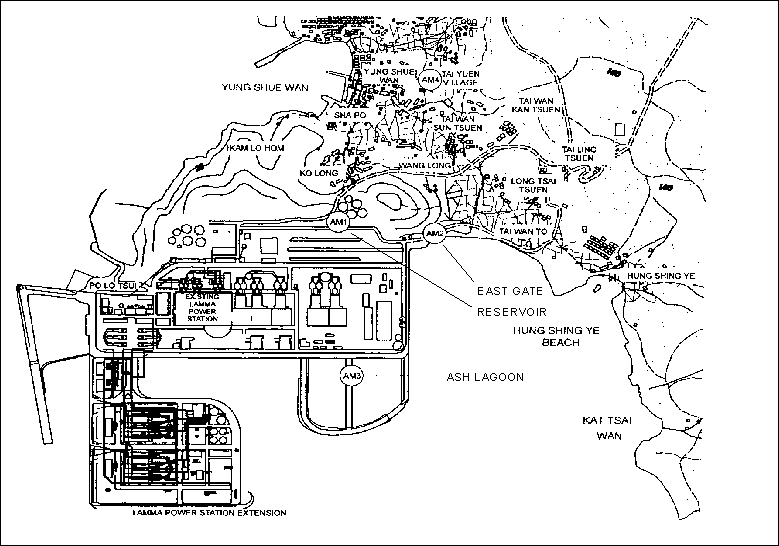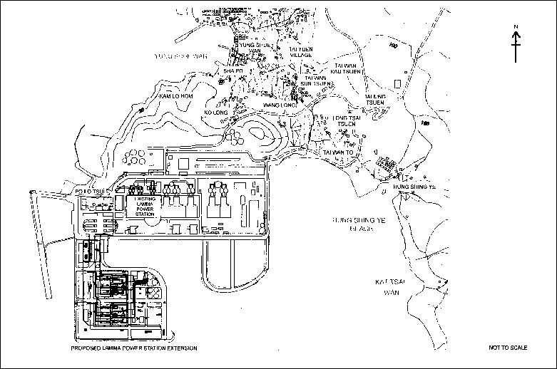
Figure 1.1 Layout of Work Site
Table of Content
1.3 Construction Works undertaken during the Reporting Month
1.4 Summary of EM&A Requirements
2.4 Monitoring Parameters, Frequency and Duration
2.5 Monitoring Procedures and Calibration Details
3.4 Monitoring Parameters, Frequency and Duration
3.5 Monitoring Procedures and Calibration Details
4.4 Monitoring Parameters, Frequency and Duration
4.5 Monitoring Procedures and Calibration Details
5.1 Review of Environmental Monitoring Procedures
5.2 Assessment of Environmental Monitoring Results
5.4 Status of Environmental Licensing and Permitting
5.5 Implementation Status of Environmental Mitigation Measures
5.6 Implementation Status of Action/Limit Plans
5.7 Implementation Status of Environmental Complaint Handling Procedures
6.1 Status of Natural Gas supply
6.2 Key Issues for the Coming Month
6.3 Monitoring Schedules for the Next 3 Months
6.4 Construction Program for the Next 3 Months
List of Tables
Table 1.1 Construction
Activities and Their Corresponding Environmental Mitigation
Measures
Table 2.1 Air Quality Monitoring Locations
Table 2.2 Air Quality Monitoring Equipment
Table 2.3 Air Quality Monitoring Parameter, Duration and Frequency
Table 3.1 Noise
Monitoring Locations
Table 3.2 Noise
Monitoring Equipment
Table 3.3 Noise
Monitoring Duration and Parameter
Table 4.1 Water Quality Monitoring Locations
Table 4.2 Water Quality Monitoring Equipment
Table 4.3 Water Quality Monitoring Parameters and Frequency
Table 4.4 Laboratory
Analysis Methodologies of Marine Water Samples
Table 5.1 Summary of
AL Level Exceedances on Monitoring Parameters
Table 5.2 Estimated
Amounts of Waste Generated in July 2001
Table 5.3 Summary of
Environmental Licensing and Permit Status
Table 5.4 Environmental Complaints / Enquiries Received in July 2001
Table 5.5 Outstanding Environmental Complaints / Enquiries Received Before
List of figures
Figure
1.1 Layout
of Work Site
Figure
1.2 Location
of Dumping Area (from 24th
May 2001)
Figure
1.3 Location
of Dumping Area (from 9th July 2001)
Figure
2.1 Location
of Air Quality Monitoring Stations
Figure
3.1 Location
of Noise Monitoring Stations
Figure
4.1 Location
of Water Quality Monitoring Stations
Appendices
Appendix A Organization
Chart
Appendix B Amount of Dredged and Dumped Marine Sediment
Appendix C Action and Limit Levels for Air Quality, Noise, Water quality Monitoring
Appendix D Environmental Monitoring Schedule
Appendix E Air Quality Monitoring Results for July 2001
Appendix F Noise Monitoring Results for July 2001
Appendix G Water Quality Monitoring Results for July 2001
Appendix H The QA/QC Procedures and Results
Appendix I Event/Action Plans
Appendix J Site Audit Summary
Appendix K Summary of EMIS
Appendix L Tentative Construction Programme
This is the fourth monthly Environmental Monitoring and Audit (EM&A) report for the Project “Construction of Lamma Power Station Extension” prepared by the Environmental Team (ET). This report presents the results of impact monitoring on air quality, noise and marine water quality for the said project in July 2001.
Air, noise and water quality
monitoring were performed. The results were checked
against the established
Action/Limit (AL) levels.
An on-site audit was conducted once per week. The implementation status of the environmental
mitigation measures, Event/Action
Plan and environmental complaint handling procedures were also checked.
Construction
Activities Undertaken
Construction activities
undertaken during the reporting month were dredging and dumping of dredged
mud. 902,632m3 of
marine mud was dredged from site and dumped at the allocated dumping area in
Cheung Chau during the month. No
filling activities were undertaken in the reporting month.
Environmental
Monitoring Works
Several environmental
monitoring works were rescheduled as shown in the following table.
|
Monitoring work |
Original Schedule |
Makeup Sampling |
Reasons |
|
Marine water
quality monitoring |
5th
July 2001 |
10th
July 2001 |
Adverse weather
conditions |
|
Marine water
quality monitoring |
7th
July 2001 |
12th
July 2001 |
Adverse weather
conditions |
|
Marine water
quality monitoring |
25th
July 2001 |
31st
July 2001 |
Adverse weather
conditions |
|
1 hour TSP
monitoring at AM1 |
15th
July 2001 |
16th July
2001 |
Power failure of
TEOM |
Other than these, all monitoring work at designated stations was performed
as scheduled in the reporting period.
Air Quality
No exceedance
of Action and Limit levels for air
quality was recorded in the
month.
Noise
Construction work was carried out during the restricted hours including
evening time, holidays and night-time under valid Construction Noise Permits. No exceedance of Action and
Limit levels for noise was
recorded in the month.
Water Quality
There were 231 cases of Action level exceedance and 148 cases of Limit Level exceedance in
the reporting month. 181 out of 379 cases of action/limit
level exceedances were contributed by TIN and NH3-N while 193 cases
by DO. For these exceedances,
comprehensive investigations had been carried out. It was found that similar measurement results were also
obtained at the control stations during the monitoring period, suggesting that
the background DO levels were also low and TIN & NH3-N levels
high. Furthermore, when compared
with EPD’s published monitoring data at the monitoring locations adjacent to
Lamma Island, all the measurement results exceeding Action/Limit Levels lay
within the range of EPD’s data.
This showed that the Action/Limit level as established by the baseline
monitoring work which was carried out during cooler season, was not appropriate
for the current water body condition.
Hence, all of these
exceedances were considered not related to site activities and have been
explained to the satisfaction of EPD.
No further action was required.
Nevertheless, HEC has started a dialogue with EPD on reviewing the
impact-monitoring programme for water quality and would revise the criteria for
establishing action and limit levels accordingly.
Site Environmental Audit
Two warning letters were
issued by EPD to the dredging contractor on 5th July 2001 and 8th
August 2001 about the malfunction of the automatic self monitoring devices
installed in the barge No. 21648V (Hang Wo 9) and 21502V respectively. The contractor has been warned by HEC
to take necessary actions to prevent them from happening again.
EPD enquired about the
conditions of the installed silt curtains by letter to HEC ref: ( ) in L/M Ax (5) to
EP2/N9/D/60 dated 1st
August 2001. A response to EPD is being prepared.
EPD
officials have inspected the marine
water monitoring work on 11th July 2001.
They were generally satisfied with the
performance of the
environmental monitoring consultant.
Site audits
were carried out on a weekly basis to monitor environmental issues on the construction site. The site conditions were generally
satisfactory. All required
mitigation measures were implemented.
Environmental Licensing and Permitting
|
Description |
Permit No. |
Valid Period |
Issued To |
Date of Issuance |
|
|
From |
To |
||||
|
Varied Environmental Permit |
EP-071/2000/A (superseded by EP-071/2000/B) EP-071/2000/B |
22/12/00 13/07/01 |
- - |
HEC HEC |
22/12/00 13/07/01 |
|
Construction Noise Permit |
GW-UW0109-01 (superseded by GW-UW0256-01 on 20/07/01) GW-UW0256-01 |
02/04/01 29/06/01 |
01/10/01 07/12/01 |
Contractor Contractor |
31/03/01 29/0601 |
|
Dumping Permit |
EP/MD/01-174 |
07/04/01 |
06/10/01 |
Contractor |
27/03/01 |
Implementation Status
of Environmental Mitigation Measures
Environmental
mitigation measures for the dredging activities as recommended in the EM&A manual were implemented in the
reporting month.
Environmental
Complaints
No
complaint against the construction
activities was received
in the reporting month.
Future Key
Issues
The future key issues to be
considered in the coming month are as follows:
-
to prepare the CNP
application for bored piling works;
-
to continue with the
preventive measures for noise exceedance and keep monitoring the performance;
-
to review the monitoring
results and to take actions, if necessary, to ensure acceptable sea water
quality;
-
to provide routine
inspection and necessary maintenance for the silt curtains.
Concluding Remarks
Except the malfunction of
the Automatic Self Monitoring Device installed in the contractor’s hopper
barges spotted by EPD on 7th July 2001 and addressed in EPD’s letter
to the contractor dated 8th August 2001, the environmental performance of the project was
generally satisfactory.
The Environmental Team (hereinafter called the “ET”) was formed within the Hongkong Electric Co. Ltd (HEC) to undertake Environmental Monitoring and Audit for “Construction of Lamma Power Station Extension” (hereinafter called the “Project”). Under the requirements of Section 6 of Environmental Permit EP-071/2000/A (varied on 13th July 2001 as EP-071/2000/B), an EM&A programme for impact environmental monitoring set out in the EM&A Manual (Construction Phase) is required to be implemented. In accordance with the EM&A Manual, environmental monitoring of air quality, noise and water quality and regular environmental audits are required for the Project.
The Project involves the construction of a gas-fired power station
employing combined cycled gas turbine technology, forming an extension to the
existing Lamma Power Station. The
key elements of the Project including the construction activities associated
with the transmission system and submarine gas pipeline are outlined as
follows.
· dredging and reclamation to form approximately 22 hectares of usable area;
· construction of six 300MW class gas-fired combined cycle units;
· construction of a gas receiving station;
· construction of a new transmission system linking the Lamma Extension to load centres on Hong Kong Island;
· laying of a gas pipeline for the supply of natural gas to the new power station
This report summarizes the environmental monitoring and
audit work for the Project for the month of July 2001
An
Environmental Management Committee (EMC) has been set up in HEC to oversee the
Project. The management structure
includes the following:
· Environmental Protection Department (The Authority);
· Environmental Manager (The Chairman of the Environmental Management Committee);
· Engineer;
· Independent Environmental Checker (IEC);
· Environmental Team (ET);
· Contractor.
The project organisation chart for the construction EM&A programme is shown in Appendix A.
1.3
Construction Works undertaken during the Reporting
Month
Construction activities undertaken during the reporting month were dredging and dumping of dredged mud. A Layout Plan showing the dredging locations for the Project is shown in Figure 1.1. The total volume of dredged material from 1st to 31st July 2001 was 902,632m3. No filling activities were undertaken in the month. Uncontaminated materials were dumped at the assigned location within the South Cheung Chau Spoil Disposal Area and the total dumped volume in July 2001 was 902,632m3. The contractor was informed by EPD (via a letter ref: ( ) in EP 60/G1/12-51 XI dated 6th July 2001) of the relocation of the Spoil Disposal Area with effect from 9th July 2001. Figure 1.2 and Figure 1.3 show dumping location for this project in July 2001. Daily records of dredged / dumped volume are presented in Appendix B.
The main construction activities carried out during the reporting month and the corresponding environmental mitigation measures are summarized in Table 1.1. The implementation of major mitigation measures in the month is provided in Appendix K.
Table 1.1 Construction Activities and Their Corresponding Environmental Mitigation Measures
|
Item |
Construction
Activities |
Environmental Mitigation Measures |
|
1 |
Dredging |
Water Quality- The number of grab dredgers operating in the site and the total dredging rate are limited; - Silt curtain are installed on the eastern, southern and north western sides of the site; - Fully-enclosed watertight grabs are used and the descent speed are controlled; - All barges for transport of dredged materials are fitted with tight bottom seals. Noise- General noise mitigation measures are employed at all work sites throughout the construction phase. Waste Management- Waste Management Plan is submitted and implemented. Dredging Waste- All vessels for marine transportation of dredged sediment are fitted with tight fitting seals to their bottom openings to prevent leakage; - Dredged waste are disposed at Licensed site – South Cheung Chau; - Records of the quantities of waste generated and disposed off-site are taken. Marine Ecology- All construction related vessels approach the site from the designated route/channel to avoid disturbance to the finless porpoise. |
1.4 Summary of EM&A Requirements
The EM&A program requires environmental monitoring
for air, noise and water
quality. Regular environmental site audits for air quality, noise, water
quality and waste management were
carried out. The detailed EM&A monitoring
work for air quality, noise
and water quality are described in Sections 2, 3 and 4
respectively.
The following
environmental audits are summarized in Section 5 of this report:
· Environmental monitoring results;
· Waste Management Records;
· Weekly site audit results;
· The status of environmental licensing and permits for the Project;
· The implementation status of environmental protection and pollution control/ mitigation measures.
Future key issues will be reported in Section 6 of this report.
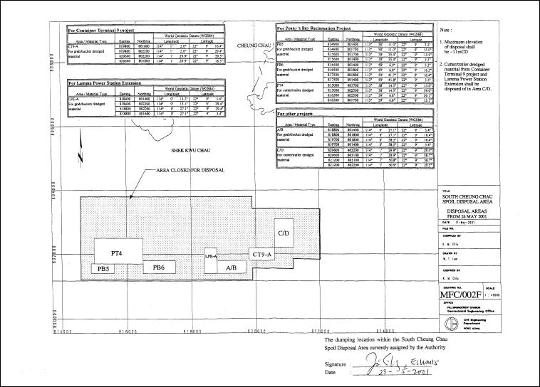
Figure 1.2 Location of Dumping Area (from 24th May 2001)
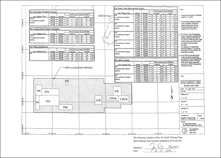
Figure 1.3 Location of
Dumping Area (from 9th July 2001)
1-hour and 24-hour TSP monitoring at agreed frequencies were conducted to monitor air
quality. The impact
monitoring data were checked against the Action/Limit Levels as determined in the Baseline
Monitoring Report (Construction Phase). Appendix C shows
the established Action/Limit Levels for Air Quality.
Three
dust monitoring locations were selected for 1-hour TSP sampling (AM1, AM2 &
AM3) while four monitoring locations were selected for 24-hour TSP sampling
(AM1, AM2, AM3 and AM4). Table 2.1 tabulates the monitoring stations. The locations of the monitoring
stations are shown in Figure 2.1.
Table 2.1 Air-Quality Monitoring Locations
|
Location I.D. |
Description |
|
AM1 |
Reservoir |
|
AM2 |
East Gate |
|
AM3 |
Ash Lagoon |
|
AM4 |
Tai Yuen Village |
Continuous
24-hour TSP air quality monitoring was performed using the GS2310 High Volume
Air Samplers (HVAS), Partisol Model 2000 Sampler and the MINIVOL Portable
Sampler at AM1&2, AM3 and AM4 respectively. TEOM Model 1400a continuous dust monitors were used to carry
out 1-hour TSP monitoring at AM1, AM2 and AM3. Table 2.2 summarises the equipment used
in dust monitoring.
Table 2.2 Air Quality Monitoring Equipment
|
Equipment |
Model and Make |
|
24-hour
sampling: HVAS
Sampler Partisol
Air Sampler MINIVOL
Portable Sampler 1-hour
sampling: Continuous
TSP Dust Meter |
Model GS2310 Anderson Instruments Inc. Partisol Model 2000 Rupprecht & Patashnick AIRMETRICS TEOM Model 1400a Rupprecht & Patashnick |
2.4
Monitoring
Parameters, Frequency and Duration
Table 2.3 summarises the monitoring parameters, duration and
frequency of air quality monitoring.
The monitoring schedule for the reporting month is shown in Appendix D.
Table 2.3 Air Quality Monitoring Parameter,
Duration and Frequency
|
Monitoring Stations |
Parameter |
Duration |
Frequency |
|
AM1 |
1-hour TSP |
1 |
3 hourly samples every 6
days |
|
24-hour TSP |
24 |
Once every 6 days |
|
|
AM2 |
1-hour TSP |
1 |
3 hourly samples every 6
days |
|
24-hour TSP |
24 |
Once every 6 days |
|
|
AM3 |
1-hour TSP |
1 |
3 hourly samples every 6
days |
|
24-hour TSP |
24 |
Once every 6 days |
|
|
AM4 |
24-hour TSP |
24 |
Once every 6 days |
2.5
Monitoring Procedures and Calibration Details
24- hour TSP Monitor:
Preparation of
Filter Papers
· Visual inspection of filter papers was carried out to ensure that there were no pinholes, tears and creases;
· The filter papers were then labelled before sampling.
·
The filter papers were equilibrated at room temperature
and relative humidity < 50% for at least 24 hours before weighing.
Field Monitoring
· During collection of the sampled filter paper, the information on the elapse timer was logged. Site observations around the monitoring stations, which might have affected the monitoring results, were also recorded. Major pollution sources, if any, would be identified and reported. The flow record chart for the previous sampling was checked to see if there was any abnormality.
· The post-sampling filter papers were removed carefully from the filter holder and folded to avoid loss of fibres or dust particles from the filter papers;
· The filter holder and its surrounding were cleaned;
· A pre-weighed blank filter paper for the next sampling was put in place and aligned carefully. The filter holder was then tightened firmly to avoid leakage;
· A new flow record chart was loaded into the flow recorder;
· The programmable timer was set for the next 24 hrs sampling period, ! 1/2 hr;
·
The post-sampling filter papers were equilibrated at
room temperature and relative humidity < 50% for at least 24 hours before
weighing.
1- hour TSP Monitor:
· The following parameters of the TEOM model dust meters are regularly checked to ensure proper functionality:
o Mass concentration;
o Total mass;
o Frequency of the tapered element;
o Electrical noise;
o Main flow;
o Auxiliary flow.
Maintenance
& Calibration
· The monitoring equipment and their accessories are maintained in good working conditions.
· Monitoring equipment is calibrated at monthly intervals. Calibration details are shown in Appendix H.
1 hour
TSP sampling at AM1 (Reservoir Area) from 15:00 to 17:59 on 15th July
2001 was void due to power failure of the TEOM TSP monitor. It was rescheduled to 16th
July 2001. Other than this, dust
monitoring was conducted as scheduled in the reporting month. All monitoring
data and graphical presentation of the monitoring results are provided in Appendix E.
Key findings and observations are provided below:
1-hour TSP
No
exceedance of 1-hour TSP Action/Limit Level was recorded in the month.
24-hour TSP
No
exceedance of 24-hour TSP Action/Limit Level was recorded in the month.
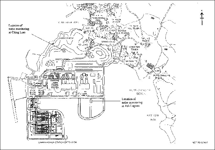
Continuous noise alarm monitoring at Ash Lagoon/Ching Lam were carried out to calculate the noise contributed by the construction activities at the two critical NSR’s, viz Long Tsai Tsuen/Hung Shing Ye and the school within the village of Tai Wan San Tsuen. The impact monitoring data for construction noise other than percussive piling were checked against the limit levels specified in the EM&A Manual. With the availability of the construction noise permits, impact monitoring for the construction work during the restricted hours was also carried out. Section 5 presents the details of the construction noise permits.
As there
were no activities for the construction of the transmission system, no manual
noise measurement at the Pak Kok Tsui residences was carried out in the
reporting month. Appendix C shows the established Action/Limit
Levels for noise.
In accordance with the EM&A manual, the identified noise monitoring locations are listed in Table 3.1 and shown in Figure 3.1.
Table
3.1 Noise Monitoring
Locations
|
Purpose of noise monitoring |
Monitoring Location |
|
Lamma Extension |
Ash Lagoon |
|
Lamma Extension |
Ching Lam |
The sound level meters used for noise monitoring complied with International Electrotechnical Commission Publications 651:1979 (Type 1) and 804:1985 (Type 1). The noise monitoring equipment used is shown in Table 3.2.
Table 3.2 Noise Monitoring Equipment
|
Equipment |
Model |
|
Sound level meter |
Rion NA-27 |
|
Calibrator (IEC 60942 Class 1) |
Rion NC-74 |
3.4 Monitoring Parameters, Frequency and Duration
Continuous noise alarm monitoring of A-weighted Leq
levels was carried out at Ash Lagoon and Ching Lam. The measurement duration and
parameter of noise monitoring were presented in Table 3.3
as follows:
Table 3.3 Noise Monitoring Duration and
Parameter
|
Location |
Time Period |
Frequency |
Parameter |
|
Ash Lagoon Ching Lam |
Daytime: 0700-1900
hrs on normal weekdays Evening-time
& holidays: 0700-2300 hrs on holidays; and 1900-2300 hrs on all other days Night-time: 2300-0700 hrs of next
day |
Daytime: 30 minutes Evening-time
& holidays: 5 minutes Night-time: 5 minutes |
30-min
LAeq 5-min
LAeq 5-min
LAeq |
3.5
Monitoring Procedures and
Calibration Details
Monitoring Procedures
The measured noise
levels (MNL's) were collected at the noise alarm monitoring
stations at Ash Lagoon and Ching Lam. The notional
background noise levels (viz. baseline noise data at
Ash Lagoon and Ching Lam) were applied to correct the
corresponding MNL's in
30-min/5-min LAeq.
A wind speed sensor was installed at Station Building
Rooftop. The wind speed signal was used to determine whether the
data from Ash Lagoon and Ching Lam noise alarm monitoring stations were affected. The instantaneous data was discarded in case the
instantaneous wind speed exceeded
10 m/s. The 30-min/5-min LAeq was
considered valid only if the amount of valid data was equal to or above 70%.
When
calibrating the noise measuring equipment, all
observations around the monitoring stations, which might have affected
the monitoring results, were recorded.
Equipment Calibration
The sound level meters and calibrators were verified by the manufacturer. Monthly calibration of the noise measuring equipment was carried out. Calibration details are shown in Appendix H.
Continuous noise monitoring was conducted at the two monitoring stations at Ash Lagoon and Ching Lam. All monitoring results and their graphical presentations are provided in Appendix F.
No
exceedance of noise Action/Limit Level was recorded in the month.
Marine
water quality monitoring at the monitoring locations adjacent to the dredging
and filling operations for Lamma Extension was carried out by a monitoring
consultant, HKPC. The purpose was
to ensure that deterioration of water quality, if any, would be detected and
that timely action could be taken to rectify the situation. The impact monitoring data were checked
against the AL levels set out
in the Baseline Monitoring Report (Construction Phase). As
there were no activities for the laying of the gas pipeline in the reporting
month, no water quality impact monitoring at the relevant stations was carried
out. Appendix C shows the established Action/Limit
Levels for water quality.
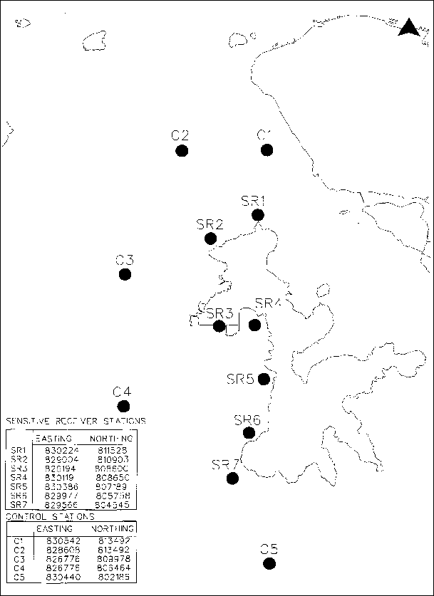
A total of 12 water quality monitoring locations were selected. 7 Sensitive Receiver
(SR) stations were chosen on the basis of their proximity to the dredging and
filling operations, 5 Marine Control stations (C) as recommended in the EIA were selected to facilitate
comparison of the water quality of the SR stations with ambient water quality
conditions. Table 4.1
describes the locations of these monitoring stations. Their locations are shown
in Figure 4.1.
Table 4.1 Water Quality Monitoring Locations
|
Type |
Monitoring Location |
HK Metric Grid E |
HK Metric Grid N |
|
Sensitive Receiver
Stations |
SR1 |
830 224 |
811 528 |
|
SR2 |
829 004 |
810 903 |
|
|
SR3 |
829 194 (829 166)1 |
808 600 (808 592)1 |
|
|
SR4 |
830 119 |
808 650 |
|
|
SR5 |
830 386 |
807 189 |
|
|
SR6 |
829 977 |
805 758 |
|
|
SR7 |
829 566 |
804 545 |
|
|
Marine Control Stations |
C1 |
830 542 |
813 492 |
|
C2 |
828 608 |
813 492 |
|
|
C3 |
826 776 |
809 978 |
|
|
C4 |
826 776 |
806 464 |
|
|
C5 |
830 440 |
802 186 |
1. Due to the construction programme, the
monitoring location SR3 was slightly shifted since the monitoring on 16th
April 2001. EPD has verbally been informed
of the shift of the monitoring location.
Table 4.2 summarizes the equipment used in the water-quality monitoring programme.
Table 4.2 Water Quality Monitoring Equipment
|
Equipment |
Detection
Limit |
|
YSI 6820 Water Quality Monitor |
Temperature: -5 to 50 0C; +/- 0.15 0C Salinity: 0 to 70 ppt; +/- 0.2 ppt Dissolved Oxygen: 0 to 200%; +/- 0.5% 0 to 20 mg/L; +/- 0.2 mg/L Turbidity: 0 to 100 and 100 to 1000 NTU; +/- 5%
of the range |
|
Trimble NT200 GPS |
Accuracy better than 3m |
|
Leica GS5 |
Accuracy better than 3m |
4.4
Monitoring
Parameters, Frequency and Duration
Table 4.3 summarizes
the monitoring parameters, frequencies and total duration of water quality
monitoring. The monitoring schedule for reporting month is shown in Appendix D.
Table 4.3 Water Quality Monitoring Parameters and Frequency
|
Monitoring Stations |
Parameters |
Frequency |
No. of Depths |
No. of Samples |
|
Sensitive Receiver Stations SR1, SR2,
SR4, SR5, SR6 & SR7 Marine Control Stations C1, C2,
C3, C4 & C5 |
· Depth, m · Temperature, oC · Salinity, ppt · DO, mg/L · DO Saturation, % · Turbidity, NTU · SS, mg/L · pH · Total inorganic nitrogen, mg/L · Un-ionised ammonia, mg/L |
3 Surface, Mid-Depth
and Bottom |
2 Mid-ebb
and Mid-flood |
For laboratory
analysis of marine water samples collected at SR3, only SS parameter was
measured.
4.5
Monitoring
Procedures and Calibration Details
Monitoring
Procedures
· The monitoring stations were accessed using survey boat to within 3m, guided by Differential Global Positioning System (DGPS).
· The depth of the monitoring location was measured using depth meter in order to determine the sampling depths. Afterwards, the water sampler was lowered into the water to the required depths of sampling. Upon reaching the pre-determined depth, a messenger to activate the sampler was then released to travel down the wire. The water sample was sealed within the sampler before retrieving.
· All in-situ measurements at each monitoring stations were taken at 3 water depths, where appropriate, namely 1m below water surface, mid-depth, and 1 meter from seabed, except where the water depth was less than 6m, the mid-depth measurement was omitted. If the water depth was less than 3m, only the mid-depth position was monitored.
· At each measurement/sampling depth, two consecutive measurements were taken. The probes were retrieved out of the water after the first measurement and then redeployed for the second measurement. Where the difference in the value between the first and the second readings of each set was more than 25% of the value of the first reading, the reading was discarded and further samplings were taken.
· The duplicate water samples for physical and chemical analysis were stored into a pre-labelled high-density polyethylene (HDPE) bottle pre-rinsed with the same water samples. The sample bottles were than packed in a cool-box (cooled to 4oC without being frozen) and delivered to a HOKLAS Laboratory for analysis upon the completion of each round of sampling.
· In addition, field information such as the general meteorological conditions and any observations regarding any significant activities in the vicinity of each monitoring location were also recorded. Major water pollution sources, if any, were identified and recorded.
Equipment
Calibration
The
equipment deployed for in-situ measurement of marine water quality was
calibrated before use. The
methodologies for the calibration follow the instruction manuals provided by
the corresponding manufacturers.
The calibration records are shown in Appendix H.
Laboratory Analysis & QA/QC
The collected marine water samples were analyzed for Suspended Solids, Total Inorganic Nitrogen and Unionized Ammonia with methodologies as summarized in Table 4.4.
Table 4.4 Laboratory
Analysis Methodologies of Marine Water Samples
|
Parameter |
Method |
Limit of Reporting
(mg/L) |
|
Suspended Solids |
APHA 17 ed 2540 D |
1.0 |
|
Total Inorganic Nitrogen |
APHA 18 ed 4500 NO2 B & NO3 E + APHA 17ed 4500-NH3B, E |
0.01 |
|
Ammoniacal Nitrogen (Un-ionized Ammonia) |
APHA 17 ed 4500-NH3 G |
0.01 (Limit of Reporting for Ammoniacal Nitrogen) x degree of ionization |
Note: The determination of unionized ammonia was based on the articles entitled “Aqueous Ammonia Equilibrium Calculation: Effect of pH and Temperature” and “Ionization of Ammonia in Seawater: Effects of Temperature, pH and Salinity” which was accepted by EPD.
In order to ensure that the laboratory analysis works were carried out properly, stringent QA/QC procedures (which includes the sample preparation as well as the subsequent instrumentation analysis) were followed. According to the requirements stipulated in the EM&A Manual, QA/QC requirements for laboratory testing include:
1) "Blind" duplicate samples analysis of 10% collected marine water samples; and
2) in-house QA/QC procedures of the testing laboratory (this includes the use of blank, batch duplicates, quality control samples and matrix spike recovery test).
Blind Duplicate:
In order to cross check the precision of the measurement results obtained from the laboratory analysis, “blind” duplicate samples of 10% of the collected marine water samples were analysed alongside the normal samples. The sample codes for the “blind” duplicates were determined by the sampling team and are not identifiable by the laboratory. The results of the “blind” duplicate samples are summarized in Appendix H.
In accordance with the QA/QC procedures of Environmental Management Laboratory of HKPC, QA/QC procedures were conducted for at least 5% of samples. A total of 858 sets of samples (for Total Inorganic Nitrogen and Unionized Ammonia) and 936 sets of samples (for Suspended Solids analysis) were received during the marine monitoring period including both ebb and flood tides. Therefore at least 5% laboratory blanks, batch duplicates, quality control samples and recovery tests for each parameter were conducted. The acceptance criteria are outlined in each type of Quality Control data.
Blank:
A laboratory blank is an analyte free matrix to which all reagents are added in the same volumes or proportions as used in the standard sample preparation to monitor contamination introduced in laboratory. The acceptance criterion for laboratory blank in Environmental Management Division (EMD) Laboratory of HKPC stipulated in EMD Quality Manual is less than the detection limit. All the laboratory blank values and acceptance criterion of the following testing parameter are summarized in Appendix H.
· Suspended Solids
· Unionized Ammonia
· Total Inorganic Nitrogen
Batch Duplicate:
Batch duplicate is an intra-laboratory split sample randomly selected from the sample batch to monitor the method precision in a given matrix. The acceptance limit of duplicate values of the following testing parameters and their duplicate results are summarized in Appendix H.
· Suspended Solids
· Unionized Ammonia
· Total Inorganic Nitrogen
Quality Control Sample:
The quality control sample is the analysis of a material with a known concentration of contaminants to determine the accuracy of results in a given matrix. The quality control samples are not applicable to all testing parameters due to the constraints of the testing parameters. The quality control samples results for the following testing parameters are shown in Appendix H.
· Unionized Ammonia
· Total Inorganic Nitrogen
Quality control sample testing is not applicable to the testing of Suspended Solids.
Matrix Spike:
Matrix spike is an intra-laboratory split of a digested sample spiked with target known concentration analyte to determine method bias in a given matrix. The matrix spike is applicable to the following tests:
· Unionized Ammonia
· Total Inorganic Nitrogen
Matrix spike testing is not applicable to testing of Suspended Solids. The matrix spike samples results are shown in Appendix H.
The QA/QC results in Appendix H indicated that the laboratory analysis works of the collected marine water samples were properly carried out and the measurement results obtained were valid in accordance with the Hong Kong Laboratory Accreditation Scheme (HOKLAS) requirements. On the other hand, the “blind” duplicate measurement results indicated that the precision of the measurements for Suspended Solids, Total Inorganic Nitrogen and Unionized Ammonia are in compliance with the HOKLAS requirements.
Due to adverse weather condition, three
marine water quality monitoring works on 5th July
2001, 7th July 2001 and 25th July 2001 were rescheduled
to 10th July 2001, 12th July 2001 and 31st
June 2001 respectively. Other than
these, marine water monitoring was conducted as scheduled in
the reporting month. All
monitoring data and graphical presentation of the monitoring results are
provided in Appendix G. Key findings and observations are provided in the following
tables:
Summary of Exceedances in Dissolved Oxygen
(Surface and Middle) in July 2001
|
Monitoring Dates |
Number of Exceedances |
Investigation Findings (if any) |
|
|
Action Level |
Limit Level |
||
|
3rd July |
10 (SR1, SR2, SR4, SR5 and SR6 during ebb tide and flood tide) |
0 |
Not related to site
activities as the measurement results at SR4 and SR6 during
ebb tide were as low as the upstream control station, suggesting the
background DO level was already low.
For the exceedances at SR1, SR2 & SR5 during ebb tide and SR1,
SR2, SR4, SR5 and SR6 during flood tide, the said exceedances lay within the range of
measurement results collected by EPD in 1999 (WM1 & SM5) suggesting that
the low DO measurement might be due to background fluctuation. |
|
9th July |
11 (All stations except SR4 during ebb tide) |
0 |
Not related to site activities as the measured results at SR1, SR2
& SR7 during ebb tide and flood tide and SR6 during flood tide lay within
the range of measurement data collected by EPD in 1999 (WM1 & SM5) which
indicated that the exceedances might be due to background fluctuation. For the exceedances at SR5 during ebb tide and flood tide, SR4
during flood tide and SR6 during ebb tide, the measurement results at
upstream control stations were as low as the said measured results,
suggesting that the background DO level was already low. |
|
10th July |
0 |
0 |
N. A. |
|
11th July |
2 (SR1and SR2 during flood
tide) |
0 |
Not related to site activities as by reviewing the literature data
form EPD in 1999 (WM1), the said measured results lay within the ranges
of measurement data, suggesting that the exceedances might be related to
background fluctuation. |
|
12th July |
4 (SR1 during ebb tide and flood tide and SR2 during
flood tide and SR7 during ebb tide) |
0 |
Not related to site activities as the measurement results at the
upstream control station is the same as of SR1 and even lower than SR7 during
ebb tide suggesting that the background DO level was already low. For the measurement results at SR1
and SR2 during flood tide both lay within the range of measurement result
collected by EPD in 1999 (WM1 & SM5) suggesting that the low
DO measurement might be due to the background fluctuation. |
|
13th July |
1 (SR7 during flood tide) |
0 |
Not related to site activities as the measurement results at upstream
control station was even lower than the said measured result, suggesting that
the background DO was already low. |
|
16th July |
9 (SR1, SR2 & SR7 during ebb tide and flood tide and SR4 & SR6 during
ebb tide and SR5 during flood tide) |
0 |
Not related to site
activities as the measurement results at upstream control stations were lower
than the monitored exceedances, suggesting that the background DO was already
low. |
|
18th July |
0 |
0 |
N. A. |
|
20th July |
3 (SR1 during ebb tide and
flood tide and SR2 during flood tide) |
0 |
Not related to site
activities as SR1 during ebb tide is located upstream as compared with the site
area and therefore the low DO level might be due to offshore discharge at the
vicinity of SR1. For the
exceedance at SR1 and SR2 during flood tide both measurements lay within the
range of measurement result collected by EPD in 1999 (WM1) suggesting the low
DO measurement might be due to the background fluctuation. |
|
23rd July |
1 (SR1 during flood tide) |
0 |
Not related to site
activities as the said exceedance lay within the range of measurement results
collected by EPD in 1999 (WM1), suggesting that the exceedances might be due
to background fluctuation. |
|
27th July |
9 (SR5, SR6, SR7 during ebb
tide and flood tide and SR1, SR2 and SR4 during flood tide) |
3 (SR1, SR2 and
SR4 during ebb tide) |
Not related to site
activities as the said exceedances were as low as the measurement results at
upstream control stations, which indicated that the background DO level was
already low. |
|
30th July |
2 (SR1 and SR7 during flood) |
1 (SR2 during flood tide) |
Not related to site activities since the measurement
results at SR1 during flood tide and SR7 during flood tide lay within the
measurement range collected by EPD in 1999 (WM1 & SM5) which indicated
that low DO might be due
to background fluctuation. For the
exceedance at SR2, no noticeable activities were observed at the vicinity of
the sampling location,
which resulted in the low DO level.
Further, the
on-site measurement result at SR2 on 31st July indicated that the DO level has
increased. Therefore the low DO
measurement at SR2 might be due
to possible background fluctuation and was not related to site activities. |
|
31st July |
5 (SR2 and SR7
during ebb tide and flood tide and SR1 during ebb tide) |
0 |
Not related to
site activities since SR1 and SR2 during ebb tide lay within the measurement
range collected by EPD in 1999 (WM1) which indicated that low DO might be due
to background fluctuation. Besides, by
comparing the measurement results at upstream control stations, the recorded
exceedances at SR2 during flood tide and SR7 during ebb and flood tide were
even higher than the measurement results at upstream control stations. |
Summary of Exceedances in Dissolved Oxygen
(Bottom) in July 2001
|
Monitoring Dates |
Number of Exceedances |
Investigation Findings (if any) |
|
|
Action Level |
Limit Level |
||
|
3rd July |
12 (All stations during ebb and flood tide) |
0 |
Not related to site activities
as the measurement results at the upstream control station were lower than
the measurement results at SR2, SR4, SR5, SR6 & SR7 during ebb tide,
suggesting that the background DO level was already low. For the exceedances at SR1 during ebb
tide and SR1, SR2, SR4, SR5, SR6 & SR7 during flood tide the recorded
values lay within the range of measurement results collected by EPD in 1999
(WM1 & SM5) suggesting that the low DO measurement might be due to
background fluctuation. |
|
9th July |
12 (All stations during ebb tide and flood tide) |
0 |
Not related to site activities as by reviewing the literature data
form EPD in 1999 (WM1 & SM5), the measured results at
SR1, SR2, SR7 during ebb tide and flood tide lay within the ranges of measurement
data, suggesting that the exceedances might be related to background
fluctuation. For the exceedances at SR4, SR5
and SR6
during ebb tide and flood tide, the
measurement results at upstream control stations were as low as said records
suggesting that the background DO level was already low. |
|
10th July |
7 (SR1 & SR7 during ebb
tide and flood tide and SR2, SR5 & SR6 during flood) |
0 |
Not related to site activities since the measurement results
at upstream control stations were even lower than the measured results at
SR5, SR6 & SR7 during flood tide and all exceedances during ebb tide,
suggesting that the background DO was already low. For the exceedances at SR1
and SR2 during flood tide, all measurement results lay within the measurement
range collected by EPD in 1999 (WM1) which indicated that low DO might be
due to background fluctuation. |
|
11th July |
10 (SR1, SR2, SR4 & SR7
during ebb tide and flood tide and SR5 during ebb tide and SR6 during flood
tide) |
0 |
Not related to site activities as by reviewing the literature data
form EPD in 1999 (WM1 & SM5), the measured results at
SR1 and SR2 during ebb tide and flood tide and SR6 during flood tide lay within
the ranges of measurement data, suggesting that the exceedances might be
related to background fluctuation. For the exceedances at SR4 and SR7 during
flood tide and all exceedances during ebb tide, the measurement results at
upstream control stations were lower than the said exceedances suggesting
that the background DO level was already low. |
|
12th July |
11 (SR1, SR2, SR5, SR6 &
SR7 during ebb tide and flood tide and SR4 during ebb tide) |
0 |
Not related to site activities since all exceedances during
ebb tide and the measured results at SR5, SR6 and SR7 were as low as the
measurement results at upstream control stations, suggesting that the
background DO was already low. For the exceedances at SR1 and SR2 during
flood tide, all measurement results lay within the measurement range
collected by EPD in 1999 (WM1) which indicated that low DO might be
due to background fluctuation. |
|
13th July |
10 (SR1, SR2, SR5, SR6 & SR7 during ebb tide and flood tide) |
0 |
Not related to site activities
as the measurement results at upstream control stations were as low as the
said reported exceedances (except result at SR1 during ebb tide), suggesting
the background DO was also low. By reviewing the
literature data form EPD in 1999 (WM1), the measurement
results at SR1 during ebb tide lay within the ranges of measurement data,
suggesting that the exceedances might be related to background fluctuation. |
|
16th July |
12 (All stations during ebb tide and flood tide) |
0 |
Not related to site activities
as the all measured results were as low as the
measurement results at upstream control, suggesting that the background DO
level was already low. |
|
18th July |
6 (SR1 & SR7 during ebb
tide and flood tide and SR2 and SR6 during flood tide) |
0 |
Not related to
site activities since the said exceedances lay within the measurement range
collected by EPD in 1999 (WM1 & SM5) which indicated that low DO might be
due to background fluctuation. |
|
20th July |
9 (SR1, SR4 & SR6 during ebb tide and flood tide and SR2, SR5 &
SR7 during flood tide) |
0 |
Not related to
site activities since the said exceedances lay within the measurement range
collected by EPD in 1999 (WM1 & SM5) which indicated that low DO might be
due to background fluctuation. |
|
23rd July |
12 (All stations during ebb tide and flood tide) |
0 |
Not related to site activities as the measurement results at upstream control stations were as low as the said exceedances (except the measurement result at SR1 during flood tide), suggesting the background DO was also low. For the exceedance at SR1 during flood tide, it lay within the range of measurement results collected by EPD in 1999, suggesting that the low DO might be due background fluctuation. |
|
27th July |
11 (SR1, SR2 SR4, SR5, SR6 during ebb tide and flood tide and SR7 during
ebb tide) |
0 |
Not related to site activities as by reviewing the literature data
form EPD in 1999 (WM1 & SM5), all exceedances during
flood tide lay within the ranges of measurement data, suggesting that the
exceedances might be related to background fluctuation. Besides, all measured
results during ebb tide were higher than the measurement results at upstream
control station which suggested that the DO were already low at vicinity of study
area. |
|
30th July |
8 (SR1 and SR7
during ebb tide and flood tide and SR4, SR5 and SR6 during flood tide) |
0 |
Not related to site activities since all measured results
lay within the measurement range collected by EPD in 1999 (WM1 & SM5) which
indicated that low DO might be due
to background fluctuation. |
|
31st July |
12 (All stations during ebb tide and flood tide) |
0 |
Not related to
site activities since the measurement results at SR2, SR4, SR5 and SR6 during
ebb tide and flood tide and SR1 and SR7 during flood tide were as low as the
measurement results at upstream control stations. For the
exceedance at SR1 and SR7 during ebb tide, the measurement result at upstream
controls were much lower than the corresponding Action Level which suggested
that the exceedances might be due to background fluctuation. |
Summary of Exceedances in Turbidity (Depth
Average) in July 2001
|
Monitoring Dates |
No. of Exceedances |
Investigation Findings (if any) |
|
|
Action Level |
Limit Level |
||
|
3rd July |
0 |
0 |
N. A. |
|
9th July |
0 |
0 |
N. A. |
|
10th July |
0 |
0 |
N. A. |
|
11th July |
0 |
0 |
N. A. |
|
12th July |
0 |
0 |
N. A. |
|
13th July |
0 |
0 |
N. A. |
|
16th July |
0 |
0 |
N. A. |
|
18th July |
0 |
0 |
N. A. |
|
20th July |
0 |
0 |
N. A. |
|
23rd July |
0 |
0 |
N. A. |
|
27th July |
0 |
0 |
N. A. |
|
30th July |
0 |
0 |
N. A. |
|
31st July |
0 |
0 |
N. A. |
Summary of Exceedances in Suspended Solids (Depth
Average) in July 2001
|
Monitoring Dates |
Number of Exceedances |
Investigation Findings (if any) |
|
|
Action Level |
Limit Level |
||
|
3rd July |
1 (SR6 during flood tide) |
1 (SR4 during flood tide) |
Not related to site activities
since SR6 located at the upstream to the site during the course of sampling
therefore the elevated SS result might be associated with the marine water
flowing from the Southwest of Lamma Island. For the exceedance at SR4, no noticeable sediment plume
migrated from the site to the sampling location was observed which resulted
in the exceedance. Further, the
measurement result at SR4 on 9th July was below the Action
level. Therefore the exceedance
is considered not related to site activities. . |
|
9th July |
0 |
1 (SR1 during ebb tide) |
Not related to site
activities since SR1 located at the upstream to the site during the course of
sampling and the marine water flowed from South to North during ebb tide.
Therefore, the elevated result might be associated with the marine water
flowing from North of Lamma Island. |
|
10th July |
0 |
0 |
N. A. |
|
11th July |
0 |
0 |
N. A. |
|
12th July |
0 |
0 |
N. A. |
|
13th July |
0 |
0 |
N. A. |
|
16th July |
0 |
0 |
N. A. |
|
18th July |
0 |
0 |
N. A. |
|
20th July |
0 |
0 |
N. A. |
|
23rd July |
0 |
1 (SR5 during flood tide) |
Not related to site activities. Based on the observation made by the
sampling team, no obvious plume was observed at the vicinity of study area which
resulted in elevated result. Beside, SR1 located at the upstream to the site during the
course of sampling therefore the elevated SS result might be associated with
the marine water flowing from the Southern area of Lamma Island. |
|
27th July |
0 |
1 (SR2 during
flood tide) |
Not
related to site activities. Firstly, based on the observation made by
the sampling team, no obvious plume was observed at the vicinity of study
area which resulted in elevated result.
Secondly, the measurement result at SR2
during ebb tide (afternoon session) was below the Action Level suggesting
that the elevated result recorded during flood tide (morning session) might be due to possible background fluctuation. Further, no
action/limit level exceedance at SR2 was found on 30th July. Hence, the exceedance was considered not
related to site activities. |
|
30th July |
0 |
0 |
N.A. |
|
31st July |
0 |
0 |
N.A. |
Summary of Exceedances in Unionized Ammonia
(Depth Average) in July 2001
|
Monitoring Dates |
Number of Exceedances |
Investigation Findings (if
any) |
|
|
Action Level |
Limit Level |
||
|
3rd July |
0 |
0 |
N. A. |
|
9th July |
6 (SR5, SR6 and SR7 during ebb tide and flood
tide) |
0 |
Not related to site activities since the measurement results of the upstream control stations were much higher than the impact station's results. |
|
10th July |
2 (SR5 & SR6 during flood tide) |
0 |
Not
related to site activities as the measurement results at the upstream control
stations were as high as the impact monitoring results, suggesting that the background concentrations
were already high. |
|
11th July |
0 |
0 |
N. A. |
|
12th July |
0 |
0 |
N. A. |
|
13th July |
1 (SR6 during flood tide) |
0 |
Not related to site activities as by
reviewing the literature data form EPD in 1999 (SM5),
the exceedance lay within the ranges of measurement data, suggesting that the
exceedances might be related to background fluctuation. |
|
16th July |
0 |
0 |
N. A. |
|
18th July |
0 |
0 |
N. A. |
|
20th July |
0 |
0 |
N. A. |
|
23rd July |
0 |
0 |
N. A. |
|
27th July |
6 (SR4, SR5, SR6 during ebb tide; SR5, SR6 and SR7 during flood
tide) |
0 |
Not related to site activities since the measurement results of
the corresponding upstream control stations were as high as those impact monitoring stations, suggesting
the background concentration was already high. |
|
30th July |
6 (SR5, SR6 and SR7 for both ebb tide and flood tide) |
0 |
Not related to site activities since the measurement results of
the corresponding upstream control stations were higher or as high as the SR5
during ebb tide as well as SR6 and SR7 during both ebb tide and flood tide
suggesting the background concentration was already high. Further, the measurement result at SR5 during
flood tide lay within the range of measurement data collected by EPD in 1999
(SM5) suggesting that the exceedances might be
related to background fluctuation. |
|
31st July |
5 (SR4, SR6 and SR7 during ebb tide; SR5 during ebb tide and flood
tide) |
0 |
Not related to site activities since the measurement results of the
corresponding upstream control stations were higher or as high as the SR5
during ebb tide and flood tide as well as SR6 and SR7 during ebb tide
suggesting the background concentration was already high. For the exceedance at SR4 during ebb
tide, the measurement result at SR4 during flood tide of the same sampling
day (afternoon session) was below the Action Level suggesting
that the said exceedance might be related to background fluctuation. |
Summary of Exceedances in Total Inorganic Nitrogen
(Depth Average) in July 2001
|
Monitoring Dates |
Number of Exceedances |
Investigation Findings (if any) |
|
|
Action Level |
Limit Level |
||
|
3rd July |
1 (SR1 during flood tide) |
11 (SR1 during ebb tide and
SR2, SR4, SR5, SR6 & SR7 during ebb tide and flood tide) |
Not related to site activities since the measurement results of the upstream control stations were higher than the results at SR4, SR5 and SR6 during ebb tide and flood tide and SR7 during ebb tide. For the exceedances at SR7
during flood tide, by reviewing the literature data
form EPD in 1999 (SM5), the measured result lay within the ranges
of measurement data, suggesting that the exceedances might be related to
background fluctuation. For
the exceedances at SR1 and SR2 during ebb tide, since SR1 and
SR2 are located at upstream of
the site during the course of sampling, suggesting
that the elevated might be due to background
fluctuation rather than site activities. Further, the exceedances at SR1 and SR2 were
persistently recorded again during flood tide,
suggesting that this might be a localized event. |
|
9th July |
1 (SR1 during ebb tide) |
11 (SR1 during flood tide and
SR2, SR4, SR5, SR6 & SR7 during ebb tide and flood tide) |
Not related to site activities since the measurement results of the upstream control stations were higher than all measured results with limit exceedance during ebb tide and the exceedances at SR7 during flood tide. By reviewing the literature data form EPD in 1999 (SM5), the exceedances at SR4, SR5 and
SR6 during flood tide lay within the ranges of measurement data, suggesting
that the exceedances might be related to background fluctuation. Besides, the measurement results at upstream control stations were higher than the corresponding Limit Level at SR2. Therefore, the said exceedances might be due to background fluctuation. Further, the exceedance at SR1 was persistently recorded again during flood tide, suggesting that this might be a localized event. Therefore the said exceedance might be a localized event at vicinity of SR1 on the sampling day. |
|
10th July |
1
(SR1
during flood tide) |
11 (SR1 during ebb tide and
SR2, SR4, SR5, SR6 & SR7 during ebb tide and flood tide) |
Not related to site activities since the measurement results of the upstream control stations were higher than the exceedances except the exceedance at SR5 during flood tide. For the exceedance at SR5 during flood tide, the measurement results at upstream control stations were higher than the corresponding Limit Level. Therefore, the said exceedances might be due to background fluctuation. |
|
11th July |
1
(SR1
during flood tide) |
11 (SR1 during ebb tide and
SR2, SR4, SR5, SR6 & SR7 during ebb tide and flood tide) |
Not related to site activities since the measurement results of the upstream control stations were higher than the exceedances except the exceedance at SR2 during ebb tide. For the exceedance at SR2 during ebb tide, the measurement results at upstream control stations were higher than the corresponding Limit Level. Therefore, the said exceedances might be due to background fluctuation. |
|
12th July |
1
(SR1
during ebb tide) |
11 (SR1 during flood tide and SR2, SR4, SR5, SR6 & SR7
during ebb tide and flood tide) |
Not related to site activities since the measurement results of the upstream control stations were higher than the results at SR1, SR4 and SR7 during ebb tide and flood tide and SR2 during ebb tide. For the exceedances at SR2 during flood tide, SR5 & SR6 during ebb tide and flood tide, the measurement results at upstream control stations were higher than the corresponding Limit Levels. Therefore, the said exceedances might be due to background fluctuation. |
|
13th July |
2 (SR1 during ebb tide and
flood tide) |
10 (SR2, SR4, SR5, SR6 and SR7 during ebb tide and flood tide) |
Not related to site activities since the measurement results of the upstream control stations were as high as the measurement results at SR1, SR2, SR4 and SR7 during ebb tide and flood tide and SR5 during flood tide, which indicated that background TIN was already high. For the exceedance at SR6 during flood tide with marine water flowing from South to North, SR6 is located at the upstream of the site during the course of sampling. Further, the measurement results at upstream control stations were higher than the corresponding Limit Levels at SR5 and SR6 during ebb tide. Therefore, the said exceedances might be due to background fluctuation. |
|
16th July |
1 (SR1 during ebb tide) |
11 (SR1 during flood tide and
SR2, SR4, SR5, SR6 & SR7 during ebb tide and flood tide) |
Not related to site activities since the measurement results of the upstream control stations were higher than the impact station’s results. |
|
18th July |
0 |
12 (All stations during ebb tide and flood tide) |
Not related to site activities since the measurement results of the upstream control stations were higher than all exceedances during flood tide and the exceedances at SR1, SR2 and SR7 during ebb tide. For the exceedances at SR4, SR5 and SR6 during ebb tide, the measurement results at upstream control stations were higher than the corresponding Limit Levels. Therefore, the said exceedances might be due to background fluctuation. |
|
20th July |
1 (SR1 during flood tide) |
11 (SR1 during ebb tide and
SR2, SR4, SR5, SR6 & SR7 during ebb tide and flood tide) |
Not related to site activities since the measurement results of the upstream control stations were higher than the impact monitoring station's results. |
|
23rd July |
1 (SR1 during flood tide) |
11 (SR1 during ebb tide and
SR2, SR4, SR5, SR6 & SR7 during ebb tide and flood tide) |
Not related to site activities since the measurement results of the upstream control stations were even higher than the results at SR4, SR5, SR6 and SR7 during ebb tide and flood tide and SR1 during flood tide. For the exceedances at SR2 during ebb tide and flood tide, the measurement results at upstream control stations were higher than the corresponding Limit Level. Therefore, the said exceedances might be due to background fluctuation. Further, SR1 is located at the upstream to the construction site during the course of sampling. Therefore, the elevated result at SR1 during ebb tide might be associated with the marine water flowing from Northern area of Lamma Island rather than the site activities. |
|
27th July |
3 (SR1 and SR7
during ebb tide; SR1 during flood tide) |
9 (SR2, SR4, SR5
and SR6 during ebb tide; SR2, SR4, SR5, SR6 and SR7 during flood tide) |
Not related to the site activities as the measurement results of
the upstream control stations were higher than the results of SR1, SR2, SR4,
SR5, SR6 and SR7 during ebb tide as well as SR4, SR5, SR6 and SR7 during
flood tide suggesting that the background concentration was already
high. Further, the
measurement results at SR1 and SR2 during flood tide were almost as high as
the data collected by EPD in 1999 (WM1). Therefore the elevated measurement results might be due to the
possible background fluctuation. |
|
30th July |
1 (SR1
during flood tide) |
11 (SR2, SR4,
SR5, SR6 and SR7 during ebb tide and flood tide; SR1 during ebb tide) |
Not related to the site activities as the measurement
results of the upstream control stations exceeded the Action and/or Limit
Levels of the corresponding monitoring stations (except SR1 during flood
tide). Regarding
the exceedance at SR1 during flood tide, the
result of the upstream control station was higher than that
at SR1 during flood tide. The said findings suggested the
background concentration was already high. |
|
31st July |
1 (SR1 during
flood tide) |
10 (SR2, SR4,
SR5, SR6 and SR7 during ebb tide and flood tide) |
Not related to the site activities as the measurement results
of the upstream control stations exceeded the Action and/or Limit Levels of
the corresponding monitoring stations suggesting the background concentration
was already high. |
There were two hundred
and thirty-one (231) cases of Action level exceedance and one hundred and
forty-eight (148) cases of Limit Level exceedance for
water quality in the reporting month.
181 out of 379 cases of action/limit level exceedances were contributed
by TIN and NH3-N while 193 cases by DO. For these exceedances, comprehensive investigations have
been carried out. It is found that
similar measurement results were also obtained at the control stations during
the monitoring period, suggesting that the background DO levels were already
low and TIN & NH3-N levels were already high. Furthermore, when compared with EPD’s
published monitoring data at monitoring locations close to Lamma Island, all
the measurement results exceeding Action/Limit Levels lay within the range of
EPD’s data. This showed that the
Action/Limit level as established by the baseline monitoring work which was
carried out during cooler season, was not appropriate for the current water
body condition.
Hence, all of these exceedances were considered not related to site
activities and have been explained to the satisfaction of EPD. No further
action was required. IEC and the
construction contractor have been informed of the exceedances accordingly as per
the requirements of the EM&A Manual. Nevertheless, HEC have started a
dialogue with EPD on reviewing the impact-monitoring programme for water
quality and would revise the criteria for establishing action and limit levels
accordingly.
Figure 4.1 Location of Water Quality Monitoring Stations
5.1
Review of Environmental Monitoring Procedures
The environmental
monitoring procedures were regularly reviewed by the Environmental Team. No modification to the existing monitoring procedures was recommended.
5.2
Assessment
of Environmental Monitoring Results
Monitoring results for Air Quality, Noise and Water Quality
The environmental monitoring results for Air Quality, Noise and Water Quality in July 2001 presented in sections 2,3 and 4 respectively are summarized in Table 5.1.
Table 5.1 Summary of AL Level Exceedances on Monitoring
Parameters
|
Item |
Parameter
Monitored |
Monitoring
Period |
No. of Exceedances In |
Event/Action
Plan Implementation Status and Results |
||
|
Action
Level |
Limit Level |
|||||
|
Air |
||||||
|
1 |
Ambient TSP (24-hour) |
01/07/01-31/07/01 |
0 |
0 |
|
|
|
2 |
Ambient TSP (1-hour) |
01/07/01-31/07/01 |
0 |
0 |
|
|
|
Noise |
||||||
|
1 |
Noise level at the critical NSR’s predicted by the noise alarm monitoring system |
01/07/01-31/07/01 |
0 |
0 |
|
|
|
2 |
Manual noise monitoring at the Pak Kok Tsui residences |
01/07/01-31/07/01 |
NA |
NA |
Construction of transmission system not yet commenced. |
|
|
Water |
||||||
|
1 |
DO (Surface & Middle) |
01/07/01-31/07/01 |
57 |
4 |
The exceedances were considered not related to the construction activities. Please refer to section 4 of the report for details. |
|
|
2 |
DO (Bottom) |
01/07/01-31/07/01 |
132 |
0 |
The exceedances were considered not related to the construction activities. Please refer to section 4 of the report for details. |
|
|
3 |
SS |
01/07/01-31/07/01 |
1 |
4 |
The exceedances were considered not related to the construction activities. Please refer to section 4 of the report for details. |
|
|
4 |
Turbidity |
01/07/01-31/07/01 |
0 |
0 |
|
|
|
5 |
NH3-N |
01/07/01-31/07/01 |
26 |
0 |
The exceedances were considered not related to the construction activities. Please refer to section 4 of the report for details. |
|
|
6 |
TIN |
01/07/01-31/07/01 |
15 |
140 |
The exceedances were considered not related to the construction activities. Please refer to section 4 of the report for details. |
|
Waste
Management Records
The estimated amounts of different types of waste
generated in July 2001 are shown in Table 5.2.
Table
5.2 Estimated Amounts of Waste
Generated in July 2001
|
Waste Type |
Examples |
Estimated
Amount (m3) |
|
Dredged Materials |
Marine Mud |
|
|
Construction Waste |
Concrete Waste, Used formwork |
0 |
|
Excavated Materials |
Rock and soil |
0 |
|
General Refuse |
Domestic wastes collected on site |
1 |
The total bulk volume of dredged material was 902,632m3. No filling took place.
Two warning letters from EPD was issued to the
contractor on 5th July 2001 and 8th August 2001 about the
malfunction of automatic self monitoring device installed in the barge No.
21648V (Hang Wo 9) and 21502V respectively. The contractor has been warned by HEC to take necessary
actions to prevent them from happening again.
EPD enquired about the conditions of the installed silt curtains by letter to HEC ref: ( ) in L/M Ax
(5) to EP2/N9/D/60 dated 1st
August 2001. A response to EPD is being prepared.
Two EPD officials from the Water Policy and Planning Group have inspected
the marine monitoring work on 11th July 2001. They were generally satisfied with the environmental performance of the monitoring consultant.
Site audits were
carried out by ET on a weekly basis to monitor environmental issues at the construction sites
to ensure that all mitigation measures were implemented timely and properly. The site
conditions were generally satisfactory.
All required mitigation measures were implemented. The weekly site
inspection results are
attached in Appendix J.
5.4 Status of Environmental Licensing and Permitting
In view of practical
difficulties in following the dredging scenarios stipulated in the EP
(EP-071/2000/A) due to unavailability of trailer dredgers and more efficient grab
dredgers that can achieve the dredging rates assumed in the EIA assessment, HEC
has applied for variation of Environmental Permit on 19th June
2001. Despite the change in
dredger configuration, the sediment loss to the surrounding water remains unchanged. The application was approved by EPD on
13th July 2001. All
permits/licenses obtained for the project are summarised in Table
5.3.
Table 5.3 Summary of Environmental Licensing and Permit Status
|
Description |
Permit No. |
Valid Period |
highlights |
Status |
|
|
From |
To |
||||
|
Varied Environmental Permit |
EP-071/2000/A EP-071/2000/B |
22/12/00 13/07/01 |
- - |
The whole construction work site. The whole construction work site. |
Superseded by EP-071/2000/B Valid |
|
Construction Noise Permit |
GW-UW0109-01 GW-UW0256-01 |
02/04/01 29/06/01 |
01/10/01 07/12/01 |
4 derrick barges, 4 dredger grabs and 6 tug boats for 0700 to 2300
& holiday 4 derrick barges, 5 dredger grabs and 6 tug boats before 2300 5 grab dredgers and 2 tug boats from 2300 to 0700 next day with a condition
restricting the location of the grab dredger (CNP063) |
Superseded
by GW-UW0256-01 Valid |
|
Dumping Permit |
EP/MD/01-174 |
07/04/01 |
06/10/01 |
Dumping at South Cheung Chau Disposal Area (Relocation of the Spoil Disposal Area with effective 24th May 2001 and 9th July 2001) |
Valid |
5.5
Implementation Status of Environmental Mitigation
Measures
Mitigation measures detailed in the permits and the EM&A Manual (Construction
Phase) are required to be implemented. An updated summary of the Environmental Mitigation Implementation Schedule (EMIS) is
presented in Appendix K.
5.6 Implementation Status of Action/Limit Plans
The Action/Event Plans for air quality, noise and water quality extracted from the EM&A Manual (Construction Phase) are presented in Appendix I.
As all the action/limit level exceedances were not related to the construction work, no further action can be devised. Nevertheless, EPD, IEC and the construction contractor have been informed of the exceedances accordingly as per the requirements in the EM&A Manual.
5.7 Implementation Status of Environmental Complaint Handling Procedures
No environmental complaint against the construction activities was received in July 2001.
Table 5.4 Environmental
Complaints / Enquiries Received in July 2001
|
Case Reference
/ Date, Time
Received / Date, Time
Concerned |
Descriptions
/Actions Taken |
Conclusion
/ Status |
|
Nil |
N/A |
N/A |
Table 5.5 Outstanding Environmental
Complaints / Enquiries Received Before
|
Case
Reference / Date, Time
Received / Date, Time
Concerned |
Descriptions /Actions Taken |
Conclusion
/ Status |
|
Nil |
N/A |
N/A |
6.1
Status
of Natural Gas supply
Based on current project schedule, HEC anticipates there is no delay in the supply of natural gas.
6.2 Key Issues for the Coming Month
Key issues to be considered in the coming month include:
Construction Noise Impact
· To estimate the noise level induced during the bored piling operation and to prepare the CNP application for the bored piling works in advance;
· To continue the preventive measures for noise exceedance and keep monitoring/ reviewing the performance.
Construction Water Impact
· To keep reviewing the monitoring results in order to take corresponding action to ensure the sea water quality;
· To provide routine inspection and necessary maintenance for the silt curtain.
6.3 Monitoring Schedules for the Next 3 Months
The tentative environmental monitoring schedules for the next 3 months are shown in Appendix D.
6.4 Construction Program for the Next 3 Months
The tentative construction program for the next 3 months is shown in Appendix L.
Except three marine water monitoring works and one 1 hour TSP monitoring work which were rescheduled due to adverse weather conditions and power failure of monitoring equipment respectively, environmental monitoring and site inspection were performed as scheduled in the reporting month. All monitoring results were checked and reviewed.
No Action/Limit level exceedance on 1-hour and 24-hour TSP level was recorded in the reporting month.
No
Action/Limit level exceedance on noise was recorded in the reporting
month.
A total of 379 cases of action/limit level exceedance on water quality parameters were recorded in the reporting month. As all the action/limit level exceedances were not related to construction activities, no further action is required.
Environmental
mitigation measures recommended in the EM&A manual for the dredging
activities were implemented in the reporting month. No environmental complaint against the construction activities
was received in the reporting
month. No prosecution was
received for this Project
in the reporting period.
Except the malpractice of the contractor spotted by
EPD on 7th July 2001, the environmental performance of the Project was generally
satisfactory.